


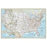


The map is big, and made with good and resistant paper. It looks good no matter from where you are looking at it. It is not negatively affected by having the light turned on in the room. So, no annoying reflections.
It came in a heavy plastic tube, and well protected.
It looks great on the wall. Guests coming in are attracted by the map, and always stop by looking for places and sharing their stories. I spend quite a lot of time looking at it and dreaming of future trips!
It is very detailed, and accurate, with easy to read fonts. Not only cities and major roads are reported (anyway, it is not a road map). Parks, peaks, lakes, and other features are also included. It covers all the USA (Alaska and Hawaii included). Part of Canada and Mexico are also included in the map, with the same details of above. It also provides geographical information (latitude and longitude) to easily locate places on the map.
A great "must" if you like travels, are curious about learning more about geography in the States, want to plan for a road trip or a vacation, and have enough space on the wall!
Download the free Kindle app and start reading Kindle books instantly on your smartphone, tablet, or computer - no Kindle device required.
Read instantly on your browser with Kindle for Web.
Using your mobile phone camera - scan the code below and download the Kindle app.

There is a newer edition of this item:

Book recommendations, author interviews, editors' picks, and more. Read it now.
Customers who viewed this item also viewed
Page 1 of 1 Start overPage 1 of 1
About the author

Huge Map
Exactly what I wanted for my son’s room. He loves walking up to the map and hearing stories of my road trips throughout life because I can show him where I’m talking about. It’s a great teaching aid to have on the wall. Certainly get one of these!
Top reviews from the United States
There was a problem filtering reviews. Please reload the page.
- Reviewed in the United States on June 26, 2014
- Reviewed in the United States on November 29, 2023
- Reviewed in the United States on March 13, 2014
- Reviewed in the United States on October 10, 2014


Top reviews from other countries
- CassReviewsReviewed in the United Kingdom on November 3, 2015
Perfect for what I need
-
